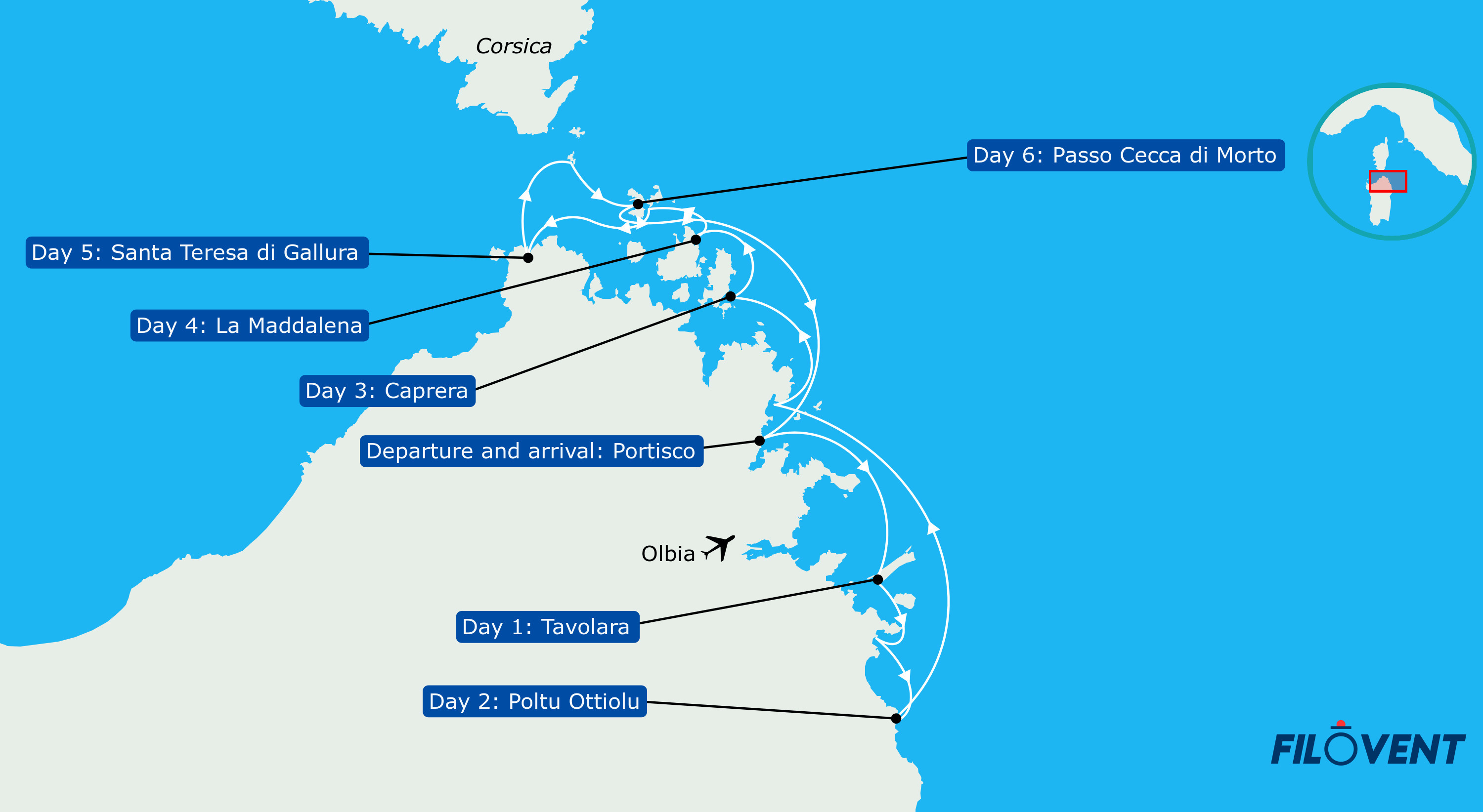
- Day 1 : Portisco → Tavolara
- Day 2 : Tavolara → Cala Brandinchi → Poltu Ottiolu
- Day 3 : Poltu Ottiolu → Cala di Volpe → Caprera
- Day 4 : Island of Caprera → Island La Maddalena
- Day 5 : Island La Maddalena → Passo Cecca di Morto → Santa Teresa di Gallura
- Day 6 : Santa Teresa di Gallura → Lavezzi → Passo Cecca di Morto
- Day 7 : Passo Cecca di Morto → Portisco
This is the account of the cruise that we took between 15 May and 22 May 2021 in the North of Sardinia, with a group of 9 friends on GACRUX, an Oceanis 51.1 rented with Filovent. This cruise, initially scheduled for 2020 but postponed because of the lockdown, left us all with unforgettable memories. The itinerary that I’m about to share with you started in the marina Cala dei Sardi in Portisco, but the stopovers which are described there also apply easily to a nearby departure base, such as the marina of Olbia, Cannigione, and even Palau, all accessible in under 40 minutes by shuttle from the airport of Olbia - Costa Smeralda.
No long crossings were to be done during this dayney. The cruises were either short crossings, or longer steps along the coast. In total, we travelled around 127 miles (235 km), which was an average of around 18 miles a day, 3 to 4 hours' of sailing per day. Depending on the tastes of each person, you can do it in a shorter time (for example, if you only want to explore the archipelago of the Maddalena), or longer (if you want to go to Corsica and spend part of the week there).
Regarding the weather, the sun shone every day, and we had rather windy weather between Sunday and Wednesday (force 5 and above, which is over 40 km/h), then it calmed down, becoming idyllic. No rain to worry about. Moreover, Sardinia is known for being even drier than Corsica. In general, depart from the principle that the wind is rather in the West / North-West region, apart from a few episodes of the Sirocco (a Southern wind coming from the Sahara) in summer. We also noted that the wind was naturally accelerated by the Venturi effect in the Bouches de Bonifacio, i.e., between Corsica and Sardinia, making sailing and especially anchoring tricky in the islands of the Maddalena and Lavezzi.

If you don’t have time to read the itinerary in detail, here are the main places of interest that I recall:
- The small archipelago of the Maddalena, which is a very lovely nature reserve (essentially the island of Caprera and the Passo Cecca di Morto between the 3 islands of Budelli, Razzoli, and Santa Maria, everything in the North of the archipelago).
- The impressive island of Tavolara, a real geological curiosity. It’s a limestone block of 5km over 1, surrounded by forests with a beautiful wild beach to the West. It culminates at 565 metres high, which makes it visible from very far away.
- The many coves in the South of Olbia, opposite Tavolara, with their crystalline waters and their sand as fine as that of the Atlantic (in particular on the splendid Cala Brandinchi). This whole area is less busy in summer than the Maddalena or the Costa Smeralda (Porto Cervo, Porto Rotondo, etc…). However, it’s worth the detour and offers good, sheltered anchorages so that you can avoid the costly ports
- The Lavezzi islands in the Bouches de Bonifacio, between Corsica and Sardinia: an exceptionally beautiful, wild, granite micro-archipelago, with wonderful turquoise water. Which just goes to show that it’s not necessary to take a boat in Corsica to go and anchor in the middle of this treasure. It is completely accessible from Sardinia!
Day 1 : Portisco → Tavolara (14 miles, 2 to 3 hours' of sailing depending on the departure port)
After the inventory and taking possession of the boat with the chief operator, we set sail and left the Cala dei Sardi at the end of the afternoon. We set sail once outside of the Gulf of Portisco, passed the Capo Figari with its high cliffs, and headed for the monumental island of Tavolara. This enormous limestone massif 565 metres high is located in the middle of the sea, 1 mile from the coast. It was extended by a small strip of sandy land to the West (Sardinia coast), the Spiaggia Spalmatore, providing a beautiful anchorage protected by the moderate West wind. We anchored there in 5 metres with a sandy base, and spent the evening in this majestic landscape. The escape had officially begun!


Day 2 : Tavolara → Cala Brandinchi → Poltu Ottiolu (9 miles, 2 hours; then 7 miles, 1h30)
We had breakfast under the gaze of the imposing Tavolara, before a small expedition on land. In the dinghy we approached a lovely beach where there was a nice bar/restaurant, then we starting climbing a hiking trail. The start was rather easy, then the hike got tougher. After one hour, we turned round before the via ferrata part which required a guide to reach the summit of the island. But from where we were, the view of Sardinia was already breath-taking and we could see our minuscule boat opposite the beach, 300 metres below!
Once we returned on-board, we set sail towards the South West, on course for the very lovely Cala Brandinchi, very well-known by the locals. The water there is an exceptional turquoise colour, and especially, I’ve never walked on sand as fine as this anywhere in the Mediterranean sea. We really felt like we were in the Atlantic. Moreover, the beach is nicknamed “Little Tahiti”. The view of Tavolara from afar is a stunning scene. We swam there in the middle of the afternoon, before returning to the South to spend the evening in Poltu Ottiolu, a charming village built around a very pretty port, well-sheltered, adjacent to a small beach. We dined in a very pretty restaurant, the Caffé Nautilus, on the quays. The meal wasn’t particularly memorable for me, but the scenery was undeniably splendid.


Day 3 : Poltu Ottiolu → Cala di Volpe → Caprera (Cala Caprese) (25 miles, 5 hours; then 12 miles, 2 hours)
The sporty day of the cruise..! 4 of us got up with the sun to start sailing. The idea is to do a long upwind leg of around 7 hours to the North to reach the archipelago of the Maddalena and to anchor in Caprera, the most Easterly island from the nature reserve. On the way, while we passed near Tavolara, we weathered a gust of williwaw, a dazzling current of cold air hurtling from the mountain to the sea, making the wind go from 20 to 50 knots in a few seconds. This phenomenon of unprecedented violence, common in the Fjords and in the “Land of Fire”, brought gusts of wind rising to 100 km/h and even higher, in a few seconds, which can dismast a boat with a too large sail surface area. Luckily, we were able to anticipate it and we set off facing the wind, alerted by the clouds of foam that it transported approaching us at top speed. The large rush of adrenaline from the cruise, no doubt!
Then the wind strengthened little by little and turned out to be more violent than anticipated (around 35 knots at noon compared with 20 knots announced), which obliged us to change our plan and use the engine to shelter in the charming Cala di Volpe, à a few kilometres to the North of Portisco, where we had taken the boat 2 days earlier. We spent the afternoon there, anchored 3 metres deep in astonishingly translucent water.A few strong gusts disturbed the boat despite everything, but the anchor held very well.Then at the end of day, with a more reasonable (force 5) wind, we set sail to Caprera where we arrived at night, lit by beautiful moonlight.We dropped anchor 6 metres deep in the Cala Caprese, a large cove well-sheltered from the West winds (one of several anchorages of the National Park of the Maddalena where anchoring is allowed), and spent an evening playing board games under a beautiful starry sky.


Day 4 : Island of Caprera → Island La Maddalena (Cala Spalmatore) (6 miles, 1 hour)
As we arrived at night, we discovered early the next morning the scenery in which we had anchored! We were in the large bay of Cala Caprese, situated to the South-East of the island of Caprera. The water is very turquoise (we started to get used to it!) and at the bottom of the bay is a fine strip of sand, giving both to the North and to the South, opposite the “continent”, if you consider that Sardinia is a continent with respect to the archipelago.
As the weather anticipated a strong wind up to the end of day and we were well-protected by a small cliff, we decided to spend the day here. 2 friends chose to rest on-board, and we others left for land in the dinghy for an impromptu trip. We went around Caprera, which is a very beautiful wild island, almost uninhabited, and well-preserved. We encountered a number of boars there, including a sow with her little ones, with which we kept our distances, as well as a few ibexes and various wild birds. One of the few homes there is the house of Giuseppe Garibaldi, the hero of Italian unification in the 19th century, who lived in Caprera as a hermit for nearly 20 years when he wasn’t involved in military conflicts. Allow around 2 hours to go round the island. Then we crossed the bridge which leads to the island of la Maddalena, a few hundreds of metres to the West of Caprera. This island, the principal one of the eponymous archipelago, is the only one there that is inhabited, with a small industrial region and a very pretty historic town centre with a port.
We had a drink there before retracing the route to return to the sailing boat. Once dinner was over, we set sail, heading for Cala Spalmatore to the North-East of the island of Maddalena. After one hour of consistent sailing to circumvent Caprera from the North, and to reach the island of la Maddalena, we moored to a buoy as night fell.


Day 5 : Island La Maddalena (Cala Spalmatore) → Passo Cecca di Morto → Santa Teresa di Gallura (5 miles, 1 hour; then 10 miles, 2 hours)
We got up in the middle of the morning, and set sail to circumvent Maddalena by the North, and slalom between it and the small reefs in the South of the three islands (Budelli, Razzoli, and Santa Maria). I say “the 3 islands”, because the latter are nearly touching. At their intersection is an amazing anchorage, the Passo Cecca di Morto.
We tacked enjoyably with a North West force 5 (around 35km/h) wind. At noon, we anchored smoothly in the South of the Passo Cecca di Morto, to shelter us conveniently for lunch. One of us gave a seagull some food, which in a few minutes attracted about fifteen of them to the back of the cockpit. Their cries, which sound like mewing, then accompanied the rest of this slightly Hitchcockian meal. It should be said that we were the only boat around.
Then we set off in the middle of the afternoon, heading for the port of Santa Teresa di Gallura, the most northerly town in Sardinia, which faces Bonifacio. On the way, the wind increased rather considerably (a good force 6, around 45 km/h) and we sailed against a rather significant swell. In fact, in the “Bouches de Bonifacio”, i.e., between Corsica and Sardinia, 1) the West wind is accelerated by the Venturi effect, easily adding a dozen knots compared to the wind observed in Corsica and in Sardinia, and 2) you are exposed to the swell of the sea which is not stopped by the coasts. At 7:00 pm, we arrived in the charming marina of Santa Teresa, at the base of a natural well-protected port. The approaches were charming and colourful. In the evening, we dined in the hills in the town centre, at the “Ristorante Da Thomas” (a very good seafood restaurant, at 25 to 50 Euro per head).


Day 6 : Santa Teresa di Gallura → Lavezzi → Passo Cecca di Morto (7 miles, 1h30; then 5 miles, 1 hour)
DFrom time in time, a good night in the port does you good! We slept well, we washed in real showers, and we had breakfast on land. 3 of us were tasked with doing some shopping, then we left the port. The night cost us 48 Euro, which is not much for a 51 foot place, although we are in the low season.
We headed for French land: the Lavezzis, more precisely to Lavezzu, the principal island in this beautiful archipelago, situated around 5 miles away in the South of Bonifacio. As the wind was low and the sea was calm, unlike the day before, it was the ideal day to anchor there. And for good reason: the arrival was almost surreal. By dropping anchor 6 metres deep, in the Cala di Giunco, South side, we anchored LITERALLY in a swimming pool, the water was so turquoise blue and translucent. Fishes, sea breams, which are safe there since the region is protected, gathered behind our cockpit, hoping that we would give them something to eat! We immediately dived into the water to swim among them (they’re not really wild!).
After a good risotto from our “nonna”, Antonio (the nickname given to our crew member cook), we took the dinghy to go to land and do a tour of the island. We stopped, of course, in the cemetery of shipwrecks of the Sémillante, this frigate of 54 metres which, in winter 1855, caught in a storm, hit a reef not far from there at full speed. The 773 crewmen tragically lost their lives, and ever since rest in peace in this paradise which is Lavezzu. A few tourists were walking on the island, but after 6:00 pm (the last boat return for Bonifacio, I presume), there was no-one left on the island, and we were really alone with the two or three boats which were anchored in the Cala Lazarina, next to our cove. While night falls, the emerald of the water darkens little by little, the sky takes on golden colours, meanwhile the blocks of granite stand proudly, immobile and eternal. After having enjoyed this unique show during the aperitif, headed for the South-West, we set sail for the 3 islands of Budelli, Razzoli and Santa Maria, before anchoring a hour later in the Passo Cecca di Morto, around 3 metres deep.


Day 7 : Passo Cecca di Morto → Portisco (24 miles, 5 hours)
A day of return ferrying, you could say… We got up a little before 8:00 am in the middle of the sublime Passo Cecca di Morto, that we had not really had the time to enjoy during our first stopover because of the wind. After our last breakfast at anchor, we set sail for Portisco. As the route was quite long and the wind was decreasing, we ended up using the engine. We then passed in front of Maddalena, Caprera, Capo Ferro, Porto Cervo, and Capo Capaccio, before anchoring in front of Porto Rotondo, near Portisco, for a late lunch. At last it was time to fill up with petrol and moor the vessel in the Cala dei Sardi, the base of our ship owner. For our last dinner, we went to a restaurant in Portisco to recall the best moments of the cruise and especially… to start talking about the next one!
A few highlights of the cruise...